Sunset, Vancouver
6405 Quebec Street
In the 1915, 1920, 1925, 1930, 1935, 1940 and 1945 city directories.
Before 1945: John G Tylor in 1915 and 1920 and J Hiles from 1925 to 1940. The 1940 name section gives the name as John Hiles, a cook. Mrs C Rowe is listed at 6405 Quebec Street in 1945; to the directory's knowledge, a family member owned it.
Open this house's bookIts history laid out as a book, chapter by chapter, each line with its page, to read here or save as a PDF to print or give.
- 1
- person the 1945 directory lists here
- 1925–1940
- the Hiles name here, in four of the seven years we've read
- *
- some member of the family owns the property, to the best of the directory's knowledge, in 1935, 1940 and 1945
- Rebuilt in 1997
- today, by the City's records
In 1915
The street section
- John G Tylorp. 140

The 6400 block of Quebec Street is read from the 1915 directory's street section, line by line. The 2400, 2500, 2600 and 2700 blocks of Quebec Street are read from every directory, 1905 to 1955.
In 1920
The household
- John G Tylera carpenter at the CPR · householderp. 628

The 6400 block of Quebec Street is read from the 1920 directory, street by street and by name, line by line. The 2400, 2500, 2600 and 2700 blocks of Quebec Street are read from every directory, 1905 to 1955.
1920Henderson's Vancouver Directory
Streets
QUEBEC

Names
In 1925
The street section
- J Hilesp. 106

The 6400 block of Quebec Street is read from the 1925 directory's street section, line by line. The 2400, 2500, 2600 and 2700 blocks of Quebec Street are read from every directory, 1905 to 1955.
In 1930
The household
- John H Hilesa cook · householderp. 316

The 6400 block of Quebec Street is read from the 1930 directory, street by street and by name, line by line. The 2400, 2500, 2600 and 2700 blocks of Quebec Street are read from every directory, 1905 to 1955.
1930Wrigley's British Columbia Directory
Streets
QUEBEC

Names
In 1935
The street section
- J Hilesmarked *p. 129

The 6400 block of Quebec Street is read from the 1935 directory's street section, line by line. The 2400, 2500, 2600 and 2700 blocks of Quebec Street are read from every directory, 1905 to 1955.
In 1940
The household
- John Hilesa cook · householderp. 272

Also at this address
- Charlotte Rowewidow of J Rowe · lives herep. 535

The 6400 block of Quebec Street is read from the 1940 directory, street by street and by name, line by line. The 2400, 2500, 2600 and 2700 blocks of Quebec Street are read from every directory, 1905 to 1955.
1940British Columbia and Yukon Directory
Streets
QUEBEC

Names
In 1945
The street section
- Mrs C Rowemarked *p. 128

The 6400 block of Quebec Street is read from the 1945 directory's street section, line by line. The 2400, 2500, 2600 and 2700 blocks of Quebec Street are read from every directory, 1905 to 1955.
The house today
A newer building, dated 1997 by the City, has the address now: the wood-frame building Goad's 1912 map draws here is gone, replaced after the 1945 directory; two doors along, 6427 still has one from before 1946, the only one on the block.
Since 1945
- 1997Today's building goes up, by the City's record.
From City of Vancouver open data (Open Government Licence – Vancouver): the property tax report (BC Assessment's years, approximate for old buildings), business licences from 1997 (the kind of business only), issued building permits from 2017 and the heritage register.
To go further on when it was built and by whom: search the City's permit registers for 6405 in Heritage Vancouver's transcription, 1901–1930, and ask the City of Vancouver Archives for its water service records, since a house usually applied for water as it was finished. Our guide has the steps.
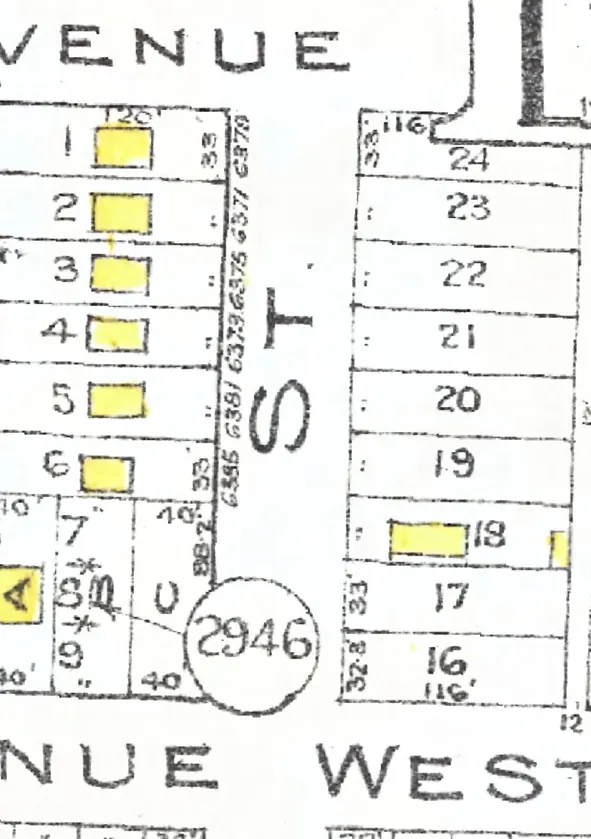
The 6400 block, year by year
Quebec Street between East 48th and East 49th Avenues, Sunset: every door each year we've read lists on the block, the way it prints them, and what stands at each today. This house is marked in red. Pick a year to read who lived at every door.
Quebec Street, the 6400 blockas the 1925 directory lists it, door by door, and what stands there today
*: some member of the family owns the property, to the best of the directory's knowledge (its own mark, printed from 1935)
West side, odd numbers
- 6405Tylor John GTylor John GHiles JHiles J H*Hiles J*Hiles J*Rowe Mrs Crebuilt
- 6417Scott JamesPike WmRoberts H TRoberts H T*Roberts H T*Roberts H T*Roberts H Trebuilt
- 6427Watson RobtJohnson StephenBoyes F CRamsden S*Ramsden S*Ramsden S*Ramsden Sstands
- 6439occupied, no name givenCopeland ChasSawyer D ASawyer A DFouquette DBoyd R A*Wood A Erebuilt
- 6451Herman HenryHerman HenryHammersley R DFaulkes J P*Faulkes J P*Faulkes J P*Faulkes J Prebuilt
- 6461vacantHollingworth WilfredExley GWatson Mrs C*Reid J*Reid J*Reid Jrebuilt
- 2of 5
- 0of 7
- 4of 7
- 5of 8
- 6of 8
- 4of 8
Quote this house
One line with its source, for a listing, a talk or a family tree. A link to this page shows the card below wherever it's shared.
6405 Quebec Street, Sunset, Vancouver, is in the 1915, 1920, 1925, 1930, 1935, 1940 and 1945 city directories; the Hiles name is listed there from 1925 to 1940. The building there today dates from 1997, by the City's record.
Source: AddressLore, addresslore.com/house/6405-quebec, from Vancouver's city directories (Vancouver Public Library) and City of Vancouver open data.
The book of 6405 Quebec Street
This address as a book
Everything this page holds about 6405 Quebec Street, gathered into one book with the page behind every line, to read here or save as a PDF to print or give. As we read more directory years for this street, the book grows with them.
Sources
The city directories of 1915 (Henderson's Greater Vancouver City Directory), 1920 (Henderson's Vancouver Directory), 1925 (Wrigley-Henderson Amalgamated British Columbia Directory), 1930 (Wrigley's British Columbia Directory), 1935 (British Columbia and Yukon Directory), 1940 (British Columbia and Yukon Directory) and 1945 (British Columbia and Yukon Directory), street and name sections where both are read, read line by line and checked against the scan (Vancouver Public Library, BC City Directories); each line above links its page. Today's buildings: City of Vancouver Open Data (property tax report 2026, property addresses, Vancouver Heritage Register; Open Government Licence – Vancouver). The City's year built is BC Assessment's figure and can be approximate for old houses. The 1912 plate: Goad's Fire Insurance Map, georectified by the City of Vancouver. Something wrong, or a name you'd like removed? Tell us.