Kensington-Cedar Cottage, Vancouver
1826 East 12th Avenue
In the 1910, 1915, 1920, 1925, 1930, 1935, 1940 and 1945 city directories, of the nine we've read for East 12th Avenue.
One after another, the directories list Frederick W McGrath (printed McGrah in 1910), who worked for the CPR, in 1910 and 1915; Joseph Deraett in 1920; and the Deraedt household (printed Deredt in 1925) from 1925 to 1945. The 1940 name section gives the name as Joseph Deraedt, a laborer. It also lists two more people here: Charles Deraedt and Clara Deraedt. The 1945 directory gives Mrs C Deraedt as the householder; the directory marks it as owned by someone in the family, as far as it knew.
Open this house's bookIts history laid out as a book, chapter by chapter, each line with its page, to read here or save as a PDF to print or give.
- 1
- person the 1945 directory lists here
- 1925–1945
- the Deredt name here (spelled Deraedt from 1930 to 1945), in five of the nine years we've read
- *
- some member of the family owns the property, to the best of the directory's knowledge, in 1935, 1940 and 1945
- Standing, built 1912
- today, by the City's records
When was it built
The records below don't agree, so we give no single year. A listing before the City's year usually means an earlier building stood on the lot, or that the City's year is later than the building. Where a listing and the City's year disagree, the listing is the stronger record: of 13 such houses we checked on the directory scans, it was right in 12.
- 1910First listed in the directories.
- 1912The City's record gives this as the year built. It is BC Assessment's figure, and can be approximate for an old house.
- 1912Goad's fire insurance map draws a wood-frame building at the street end of the lot.
In 1905
The 1905 directory lists East 12th Avenue but not 1826.
East 12th Avenue is read from the 1905 directory's street section, line by line.
In 1910
The street section
- Frederick W McGrahemployee C P Rp. 201

East 12th Avenue is read from the 1910 directory, street by street and by name, line by line.
1910Henderson's City of Vancouver and North Vancouver Directory Part 1
Streets
EAST 12TH
In 1915
The street section
- Frederick W McGrathp. 205

East 12th Avenue is read from the 1915 directory's street section, line by line.
In 1920
The street section
- Joseph Deraettp. 186

Also at this address
- Joseph Dereatha laborer · householderp. 167

East 12th Avenue is read from the 1920 directory, street by street and by name, line by line.
1920Henderson's Vancouver Directory
Streets
EAST 12TH
Names
In 1925
The street section
- J Deredtp. 166

East 12th Avenue is read from the 1925 directory's street section, line by line.
In 1930
The household
- Joseph Deraedthouseholderp. 182

Also at this address
- J Durta longshoreman · lives herep. 202

East 12th Avenue is read from the 1930 directory, street by street and by name, line by line.
1930Wrigley's British Columbia Directory
Streets
EAST 12TH

Names
In 1935
The street section
- J Deraedtmarked *p. 194

East 12th Avenue is read from the 1935 directory's street section, line by line.
In 1940

East 12th Avenue is read from the 1940 directory, street by street and by name, line by line.
1940British Columbia and Yukon Directory
Streets
EAST 12TH

Names
In 1945
The street section
- Mrs C Deraedtmarked *p. 195

East 12th Avenue is read from the 1945 directory's street section, line by line.
The house today
1826 East 12th Avenue still has a building from before 1946, as does 1816 next door; the City dates it to 1912, after the 1910 directory, so it may not be the building that directory lists (inferred).
To go further on when it was built and by whom: search the City's permit registers for 1826 in Heritage Vancouver's transcription, 1901–1930, and ask the City of Vancouver Archives for its water service records, since a house usually applied for water as it was finished. Our guide has the steps.
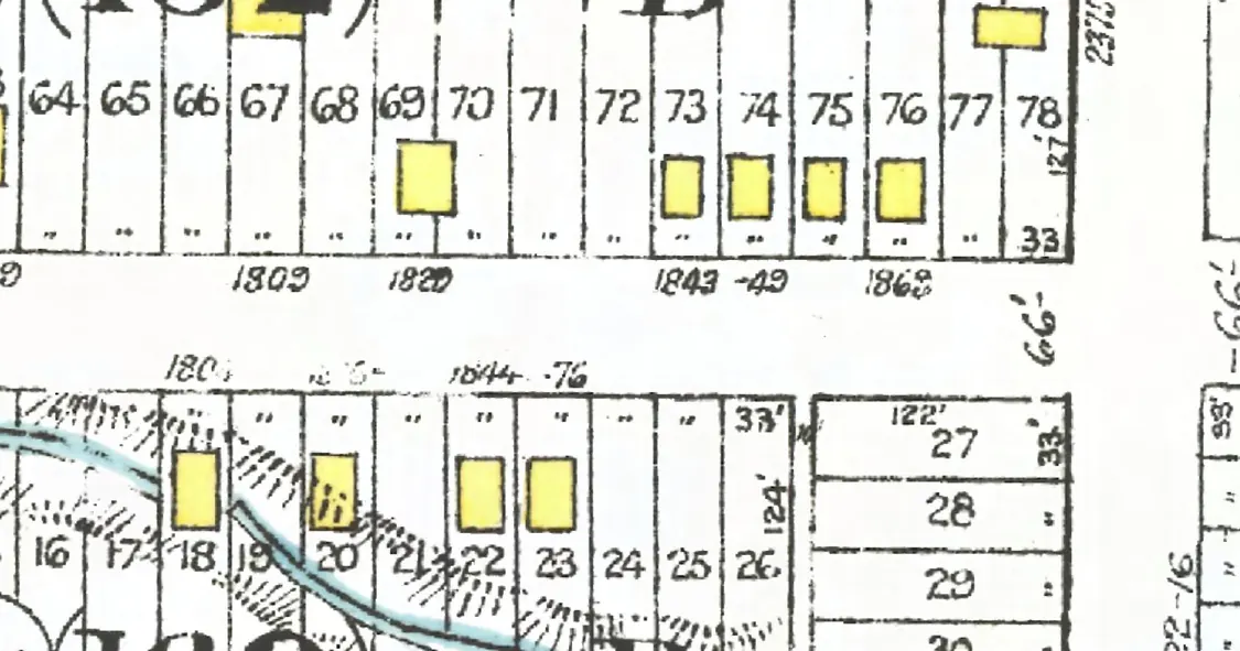
The 1800 block, year by year
East 12th Avenue, on the stretch it shares with the 1700 block, between Commercial and Victoria Drives, Kensington-Cedar Cottage: every door each year we've read lists on the block, the way it prints them, and what stands at each today. This house is marked in red. Pick a year to read who lived at every door.
East 12th Avenue, the 1800 blockas the 1945 directory lists it, door by door, and what stands there today
*: some member of the family owns the property, to the best of the directory's knowledge (its own mark, printed from 1935)
The 1905 directory lists no one on this block.
North side, odd numbers
- 1803Butcher GMcMillan J C*Cormick W*Rutter Mrs M Erebuilt
- 1809vacantnot listednot listednot listednot listednot listednot listedgone
- 1819*Miller W Hgone
- 1829Northall George“Foreigners”Zart HenryMacKenzie JRogers Mrs L EvacantStevens A HStevens A Hrebuilt
- 1833*Mason H WMason H Wrebuilt
- 1837*Perry G E*Wright W G*Wright W Gstands
- 1843Barbour John Gnot listedWotten W TPaterson K*Paterson K*Paterson K*Paterson Krebuilt
- 1849Ebbett WmEbbett Wm WEbbett W WEbbett W W*Ebbett W W*Ebbett G P*Ebbett Mrs G Pstands
- 1863vacantMcCreadie ThosLa Bossiere CLa Bossiere C*La Bossiere Miss BHall S C RHall S C Rgone
- 1869vacantGilmore DavidBenson W PDarlington T*Darlington T*Darlington T*Darlington Tgone
- 1879Caldwell Albert Wnot listednot listednot listednot listednot listednot listednot listedgone
South side, even numbers
- 1804Gillmore C RMatthews Robt HCochrane GPhillips T MManning E JPayie R NMohan Wstands
- 1816Kemp Libbie WKemp Mrs Libbie WKendall FredkKendall FKendall F*Kendall F*Kendall F*Sutherland A Dstands
- 1826McGrah Frederick WMcGrath Fredk WDeraett JosephDeredt JDeraedt J*Deraedt J*Deraedt J*Deraedt Mrs Cstands
- 1840Chadwick —Hunter AMostar W*Mostar W*Mostar W*Mostar Wstands
- 1842Knight Joseph WPage B JKnight J WKnight J W*Knight Mrs E*Stambuski JVine J Hstands
- 1844Oughton JohnMorse Chas Hnot listednot listednot listednot listednot listedgone
- 1858Hardy F JReid C JAllwood C*Bailey L Cstands
- 1866vacantAnderson H C*Mayes FCoates N Fstands
- 2of 2
- 1of 6
- 2of 9
- 5of 10
- 8of 11
- 6of 13
- 9of 15
Quote this house
One line with its source, for a listing, a talk or a family tree. A link to this page shows the card below wherever it's shared.
1826 East 12th Avenue, Kensington-Cedar Cottage, Vancouver, is in the 1910, 1915, 1920, 1925, 1930, 1935, 1940 and 1945 city directories; the Deredt name is listed there from 1925 to 1945. A building from before 1946 still stands there: the City's record gives 1912 as the year built.
Source: AddressLore, addresslore.com/house/1826-east-12th-avenue, from Vancouver's city directories (Vancouver Public Library) and City of Vancouver open data.
The book of 1826 East 12th Avenue
This address as a book
Everything this page holds about 1826 East 12th Avenue, gathered into one book with the page behind every line, to read here or save as a PDF to print or give. As we read more directory years for this street, the book grows with them.
Sources
The city directories of 1905 (Henderson's City of Vancouver Directory), 1910 (Henderson's City of Vancouver and North Vancouver Directory Part 1), 1915 (Henderson's Greater Vancouver City Directory), 1920 (Henderson's Vancouver Directory), 1925 (Wrigley-Henderson Amalgamated British Columbia Directory), 1930 (Wrigley's British Columbia Directory), 1935 (British Columbia and Yukon Directory), 1940 (British Columbia and Yukon Directory) and 1945 (British Columbia and Yukon Directory), street and name sections where both are read, read line by line and checked against the scan (Vancouver Public Library, BC City Directories); each line above links its page. Today's buildings: City of Vancouver Open Data (property tax report 2026, property addresses, Vancouver Heritage Register; Open Government Licence – Vancouver). The City's year built is BC Assessment's figure and can be approximate for old houses. The 1912 plate: Goad's Fire Insurance Map, georectified by the City of Vancouver. Something wrong, or a name you'd like removed? Tell us.