Before 1940: Thomas M Rae Jr, a motor at the BC Electric Railway, in 1920, and Elizabeth A Kirby, widow of W Kirby, in 1930. Joseph Filippone, a miner, shared 1033 Seymour Street in 1940 with two people under other surnames.
Open this house's bookIts history laid out as a book, chapter by chapter, each line with its page, to read here or save as a PDF to print or give.
- 3
- people the 1940 directory lists here
- *
- some member of the family owns the property, to the best of the directory's knowledge, in 1940
- Still standing
- today, by the City's records
- 1925
- the year built, by the City's record
In 1920
The household
- Thomas M Rae Jra motor at the BC Electric Railway · householderp. 516

Also under the Rae name
- Alex H C Raea machinist · lives herep. 516
For 1920 this is who the directory's list of residents by name puts at 1033, from the address on each person's line. We haven't read that year's door-by-door street list yet.
1920Henderson's Vancouver Directory
Names
In 1930


For 1930 this is who the directory's list of residents by name puts at 1033, from the address on each person's line. We haven't read that year's door-by-door street list yet.
1930Wrigley's British Columbia Directory
Names
In 1940


Seymour Street is read from the 1940 directory, street by street and by name, line by line.
1940British Columbia and Yukon Directory
Streets
SEYMOUR

Names
The house today
1033 Seymour Street still has a building from before 1946, as does 1035 next door; the City dates it to 1925, after the 1912 map, so it may have replaced the wood-frame building drawn there (inferred).
Since 1940
- 1965A major renovation, by BC Assessment's record.
From City of Vancouver open data (Open Government Licence – Vancouver): the property tax report (BC Assessment's years, approximate for old buildings), business licences from 1997 (the kind of business only), issued building permits from 2017 and the heritage register.
To go further on when it was built and by whom: search the City's permit registers for 1033 in Heritage Vancouver's transcription, 1901–1930, and ask the City of Vancouver Archives for its water service records, since a house usually applied for water as it was finished. Our guide has the steps.
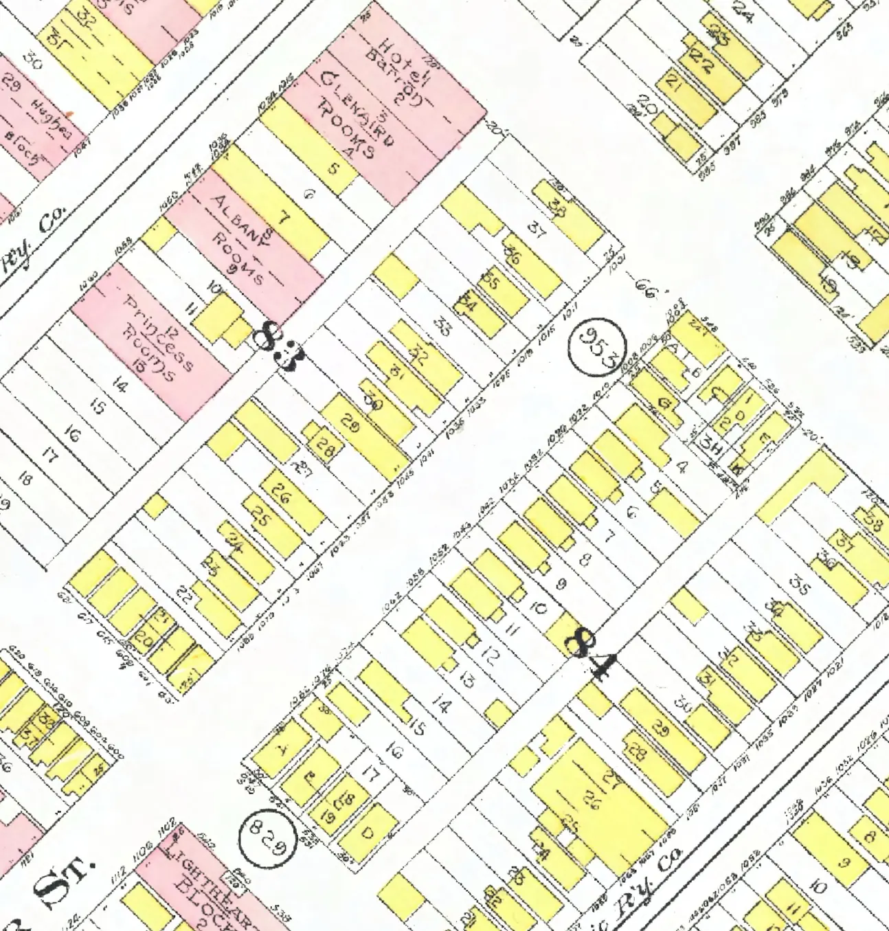
The 1000 block, year by year
Seymour Street between Nelson and Helmcken Streets, Downtown: every door each year we've read lists on the block, the way it prints them, and what stands at each today. This house is marked in red. Pick a year to read who lived at every door.
Seymour Street, the 1000 blockwith the householder the 1920 name section gives at each door, and what stands there today
*: some member of the family owns the property, to the best of the directory's knowledge (its own mark, printed from 1935)
West side, odd numbers
- 1001Lamarre GeoBelmont Serv Starebuilt
- 1011King ChasMcLean Mrs MaryDixie Chicken Inngone
- 1025Spence WmAuto Radiator & Lampgone
- 1033Rae Thos M JrKirby Eliz A*Filippone Jstands
- 1035Rowan WmBearing Supply Housestands
- 1045Dunn Thos AHendrickson HarryKirk J D Hrebuilt
- 1047Van Radio Engsgone
- 1053Lawson Richd ALawson Richd A*Lawson R Agone
- 1063Desrosiers MagloireDudney John HDemme Mrs Z +1gone
- 1067Morgan HerbtWhite Alex*Naples Jrebuilt
- 1073McCarry EdwMcCarry Edw*McCarry Egone
- 1079Watkins Clarence WArthur Mrs EvelynBattaye J Egone
- 1083Lawrence HarryFraser Peter GBarrow T Wgone
East side, even numbers
- 1002Howe Harvey RCalifornia Grorebuilt
- 1006Mariacher AlphonsoBramwell NormanPac Clnrs +1gone
- 1008Thompson Stanley AIaci FrankIaci Jgone
- 1010Dearman Mrs MarthaCurran Albt BHowson Hrebuilt
- 1022Reynolds Norman AReynolds Norman A*Iaci Frebuilt
- 1026Westland MaryBrown Lindley JDragan Mrs G Mgone
- 1032Lacey JosephBrunet Jos*Nyhus Erebuilt
- 1036Asp WmMathie Mrs JanetNelson Mrs M Fgone
- 1042Lewis Wm HCarlson A EdwinBerst Mrs Arebuilt
- 1046Elliott WmMichielsen JohnWatson Mrs Igone
- 1052McKay MarjorieWilson JasPenney W Brebuilt
- 1058Colwell Walter SColwell Walter SMacLean Miss Agone
- 1062Muir AnnieTenen LeviTenen L +1gone
- 1074Wood Jamesvacantgone
- 1076Bell Royal*Penman Tgone
- 1082Mariacher Louis AIaci Jos Dvacantrebuilt
- 4of 22
- 4of 20
Quote this house
One line with its source, for a listing, a talk or a family tree. A link to this page shows the card below wherever it's shared.
1033 Seymour Street, Downtown, Vancouver, is in the 1920, 1930 and 1940 city directories. A building from before 1946 still stands there: the City's record gives 1925 as the year built.
Source: AddressLore, addresslore.com/house/1033-seymour, from Vancouver's city directories (Vancouver Public Library) and City of Vancouver open data.
The book of 1033 Seymour Street
This address as a book
Everything this page holds about 1033 Seymour Street, gathered into one book with the page behind every line, to read here or save as a PDF to print or give. As we read more directory years for this street, the book grows with them.
Sources
The city directories of 1920 (Henderson's Vancouver Directory, name section), 1930 (Wrigley's British Columbia Directory, name section) and 1940 (British Columbia and Yukon Directory), street and name sections where both are read, read line by line and checked against the scan (Vancouver Public Library, BC City Directories); each line above links its page. Today's buildings: City of Vancouver Open Data (property tax report 2026, property addresses, Vancouver Heritage Register; Open Government Licence – Vancouver). The City's year built is BC Assessment's figure and can be approximate for old houses. The 1912 plate: Goad's Fire Insurance Map, georectified by the City of Vancouver. Something wrong, or a name you'd like removed? Tell us.