A house biography
630 East 10th Avenue
Mount Pleasant, Vancouver
1915–1945
630 East 10th Avenue
Who lived there from 1915 to 1945, read line by line from Vancouver's city directories, with the page behind every line
Contents
- The house
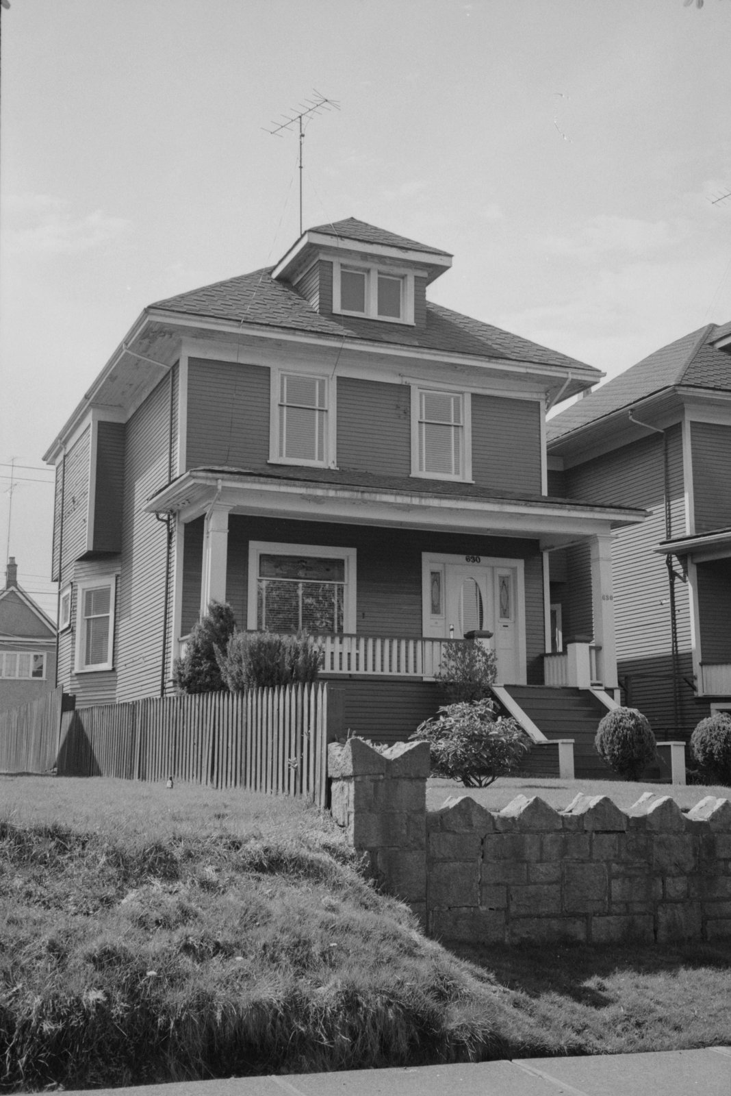
- Plate I, the house in an archive photoApril 1974
- Before the first listing1905 to 1910
- IThe Slumkoskis1915
- IIThe McRaes1920–1935
- IIIThe Grays1940–1945
- Also at this address1940
- The 600 block, decade by decade1905–1945
- The house today
- Sources, page by page
AddressLore, Vancouver, 2026
Prologue
The house
For four directories, 1920 to 1935, the McRae name is listed here (spelled MacRae from 1925 to 1935), starting with Farquhar McRae; the directory marks it * in 1935 (some member of the family owns the property, to the best of the directory's knowledge). The 1930 name section gives Farquhar MacRae, a bridge builder, at this address (page 471), matched to the 1925, 1930 and 1935 listings here by first name or initials (inferred). In 1940 the name section also gives James Gray, a steelworker at Hamilton Bridge, here (page 237), tied to the 1940 and 1945 listings by first name or initials (inferred).


A permit to build two frame houses at 624 & 630 East 10th Avenue, this one among them, was taken out in February 1910 by R H McDonald, owner and builder: $4,000 for the two.
Plate I
Before the first listing
1905 to 1910: the address is not listed in the directories.
Chapter I
The Slumkoskis
the household, 1915
William F Slumkoski lived at 630 East 10th Avenue in 1915.
1915
Street section, as printed
- Slumkoski Wm F
Chapter II
The McRaes
the household, 1920 to 1935
By 1920 Farquhar McRae lived at 630 East 10th Avenue. The 1920 name section doesn't list this household.
1920
Street section, as printed
- McRae Farquhar
1925
Street section, as printed
- MacRae F
1930
Farquhar MacRae worked as a bridge builder and headed the household at 630 East 10th Avenue in 1930.
Street section, as printed
- MacRae F
Name section, as printed
MacRae Farquhar bridge bldr (none) h 630 East 10th Avenue
1935
F MacRae is listed at 630 East 10th Avenue in 1935.
Street section, as printed
- *MacRae F
Chapter III
The Grays
the household, 1940 to 1945
James Gray, a steelworker at Hamilton Bridge, shared 630 East 10th Avenue in 1940 with one person under another surname.
1940
Street section, as printed
- Gray J
Name section, as printed
Gray Jas stlwkr Hamilton Bridge h 630 East 10th Avenue
1945
Street section, as printed
- *Gray J
1940
Also at this address
from the name section
The 1940 name section gives this address for John Cockrill, under a surname no household here was listed under. The directory doesn't say whether this person boarded, rented a room or was family.
1940
Name section, as printed
Cockrill John r 630 East 10th Avenue
The street
The 600 block, decade by decade
East 10th Avenue, Mount Pleasant, every door the directories list

1910
Eleven doors listed and one shop or business.
North side
- 617Miles Hubert, laborer
- 623Chambers Arthur H, photographer
- 635Sharp Wallace, employee laundry
- 643Sacred Robert
- 649Allen Harry, real estate
- 657Lang N
South side
- 616Bennett Thomas
- 642Rogers William G, real estate
- 658Payton Rupert, printer
- 662Stinson Wm John
- 672Ford John J, patternmaker
Street section, p. 191

1915
Eleven doors listed.
North side
- 623Chambers Arthur H
- 635Sharp Wallace
- 643Green Regd F
- 649Harford Herbt
- 657Lang Nels
South side
- 616Bennett John W
- 624Sutherland Robt
- 630Slumkoski Wm F
- 642Mole John H
- 658Efford John J
- 662Thompson —
Street section, p. 198

1920
Eleven doors listed.
North side
- 623Lister Cyril
- 635Sharp Wallace
- 643Green Regd F
- 649Ross Fred H
- 657Lang Nels
South side
- 616Bennett John W
- 624Sutherland Mrs Barbara
- 630McRae Farquhar
- 642Mole Wm
- 658Efford John J
- 662Horning Geo
Street section, p. 179

1925
Eleven doors listed.
North side
- 623Lister C
- 635Harris G W
- 643Fortune J
- 657Croves —
South side
- 616Bennett J W
- 624Davidson W
- 630MacRae F
- 642Pomeroy J R
- 646McGarvey N
- 658Efford J J
- 662Smith R E
Street section, p. 159

1930
Eleven doors listed and two vacant.
North side
- 623Sidaway J
- 635Goodman J
- 643Atkinson J R
- 649vacant
- 657vacant
South side
- 616Bennett J W
- 624Davidson W
- 630MacRae F
- 642Fleming Mrs K
- 658Efford Mrs S A
- 662Gardner J
Street section, p. 210

1935
Eleven doors listed.
North side
- 623*Sidaway J
- 635*Goodman J
- 643*Froud F J
- 649Clarke F S
- 657Harrington A L
South side
- 616*Bennett J W
- 624*Davidson W
- 630*MacRae F
- 642Poole J F
- 658Elder G O
- 662*Wright Mrs S E


1940
Eleven doors listed.
North side
- 623*Sidaway J and one more
- 635*Goodman J
- 643*Froud F J
- 649Williams A R
- 657Hutchings R M
South side
- 616*Bennett J W
- 624*Davidson W
- 630Gray J
- 642Poole J F
- 658Elder G O
- 662*McCready W R
Street section, p. 198

1945
Twelve doors listed.
North side
- 623*Eide Mrs M and two more
- 629*Ferris A
- 635James T A
- 643*Froud F J
- 649*Williams A E
- 657Johnston G E
South side
- 616occupied, no name given
- 624*Davidson W
- 630*Gray J
- 642Poole J F
- 658*Elder Mrs A M
- 662*Wright Miss D E
Street section, p. 186

- 0of 1
- 4of 9
- 7of 11
- 4of 10
- 4of 9
- 5of 9
- 7of 11
- 6of 10
Epilogue
The house today
630 East 10th Avenue still has a building from before 1946: the City's assessment record gives 1907 as its year built. Today's building at 630 is very likely the wood-frame one on the 1912 map (inferred): its building permit dates from 1910, before the map was drawn.
The directories in this book stop in 1945. What they printed at 630 East 10th Avenue is in the chapters before this one, every line with its page, so anyone can check it.
Sources
The page behind every line
Every year here comes from that year's printed city directory, held by the Vancouver Public Library. Canvassers compiled each one door to door, so a listing is who they recorded at the door, not a legal record of who owned or rented the house. Names are copied as printed, spellings and all. The street section lists each address in order; the name section lists each person with their work and address, which is where the jobs come from. h marks a householder, r someone living there, wid a widow. *: some member of the family owns the property, to the best of the directory's knowledge (its own mark, printed from 1935).
Anything we infer (a likely build date, a misprinted number, a renumbered address) is marked as inferred. Names are shown up to 1945; later years say only how the address was used. We link the library's page images and never reprint them.
Pages cited
- 1905Henderson's City of Vancouver Directory: street section p. 110
- 1910Henderson's City of Vancouver and North Vancouver Directory Part 1: street section p. 191
- 1915Henderson's Greater Vancouver City Directory: street section p. 198
- 1920Henderson's Vancouver Directory: street section p. 179
- 1925Wrigley-Henderson Amalgamated British Columbia Directory: street section p. 159
- 1930Wrigley's British Columbia Directory: street section p. 210; name section p. 471
- 1935British Columbia and Yukon Directory: street section p. 186, p. 187
- 1940British Columbia and Yukon Directory: street section p. 198; name section p. 118, p. 237
- 1945British Columbia and Yukon Directory: street section p. 186

The 1912 map: Goad's Fire Insurance Map, georectified by the City of Vancouver. Today's buildings, the heritage register and the years since 1955: City of Vancouver open data. Both under the Open Government Licence – Vancouver. The photograph: City of Vancouver Archives, CVA 1095-03348, copyright City of Vancouver.
Something wrong, or a name you'd like removed? Tell us.
Compiled by AddressLore, Vancouver, November 2026. Set in Libre Caslon.
A house biography
Vancouver, from the city directories
Another address?
Every house has its book
Find yours by its address: