A house biography
2063 Napier Street
Grandview-Woodland, Vancouver
1930–1945
2063 Napier Street
Who lived there from 1930 to 1945, read line by line from Vancouver's city directories, with the page behind every line
Contents
- The house
- Plate I, Napier Street in an archive photo1932
- Before the first listing1908 to 1925
- IThe Maynes1930
- IIThe McKeowns1935
- IIIThe Woodards1940
- IVThe Tysses1945
- The 2000 block, decade by decade1908–1945
- The house today
- Sources, page by page
AddressLore, Vancouver, 2026
Prologue
The house
Four households in four directories, 1930 to 1945, none of them listed twice, the first W Mayne and the last E T Tysse. The 1930 name section gives William R Mayne, a trackman, at this address (page 494), matched to the 1930 listing here by first name or initials (inferred). In 1940 the name section also gives Richard A Woodard, a salesman at Belding-Corticelli, here (page 672), tied to the 1940 listing by first name or initials (inferred).


The City's record dates the house to 1925.
Plate I
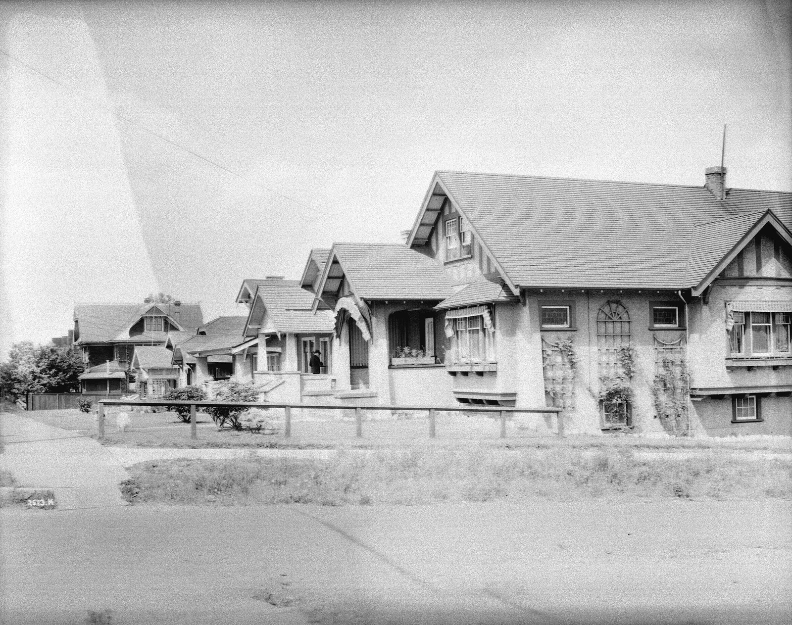
Before the first listing
1908 to 1925: the address is not listed in the directories.
Chapter I
The Maynes
the household, 1930
At 2063 Napier Street in 1930, the householder is William R Mayne, a trackman.
1930
Street section, as printed
- Mayne W
Name section, as printed
Mayne Wm R trackmn h 2063 Napier
Chapter II
The McKeowns
the household, 1935
By 1935 A W McKeown lived at 2063 Napier Street.
1935
Street section, as printed
- McKeown A W
Chapter III
The Woodards
the household, 1940
Richard A Woodard worked as a salesman at Belding-Corticelli and headed the household at 2063 Napier Street in 1940.
1940
Street section, as printed
- Woodard R A
Name section, as printed
Woodard Richd A slsmn Belding-Corticelli h 2063 Napier
Chapter IV
The Tysses
the household, 1945
E T Tysse is listed at 2063 Napier Street in 1945.
1945
Street section, as printed
- *Tysse E T
The street
The 2000 block, decade by decade
Napier Street, Grandview-Woodland, every door the directories list
The 1908, 1909, 1910, 1911, 1912 and 1913 directories list no one on this block.


1925
Three doors listed.
North side
- 2057Price D
- 2091McTaggart N
South side
- 2060occupied, no name given
Street section, p. 89

1930
Eight doors listed.
North side
- 2037Wilson O M
- 2047Vicars J G
- 2057Price D
- 2063Mayne W
- 2071Krause H S
- 2081Wynne J W
- 2091McTaggart N
South side
- 2060Watson Mrs —
Street section, p. 123

1935
Seven doors listed.
North side
- 2047*Vicars J G
- 2057Berry S E
- 2063McKeown A W
- 2071*Krause H S
- 2081Lockhead A
- 2091*McTaggart N
South side
- 2060Watson Miss L G
Street section, p. 111

1940
Seven doors listed and two vacant.
North side
- 2047*Vicars J G
- 2057*Plamback E H
- 2063Woodard R A
- 2071vacant
- 2081Lochhead A
- 2091Mitton C W
South side
- 2060vacant
Street section, p. 117

1945
Seven doors listed.
North side
- 2047*Soules Mrs M
- 2057*Moan O
- 2063*Tysse E T
- 2071*Magnussen M G
- 2081Lochhead Mrs M
- 2091*Hansen H
South side
- 2060Watson Miss L G
Street section, p. 109

- 0of 1
- 2of 2
- 4of 7
- 2of 5
- 1of 5
Epilogue
The house today
2063 Napier Street still has a building from before 1946: the City's assessment record gives 1925 as its year built.
Since 1945
- 1965A major renovation, by BC Assessment's record.
- 1967A major renovation, by BC Assessment's record.
From City of Vancouver open data (Open Government Licence – Vancouver): the property tax report (BC Assessment's years, approximate for old buildings), business licences from 1997 (the kind of business only), issued building permits from 2017 and the heritage register.
The directories in this book stop in 1945. What they printed at 2063 Napier Street is in the chapters before this one, every line with its page, so anyone can check it.
Sources
The page behind every line
Every year here comes from that year's printed city directory, held by the Vancouver Public Library. Canvassers compiled each one door to door, so a listing is who they recorded at the door, not a legal record of who owned or rented the house. Names are copied as printed, spellings and all. The street section lists each address in order; the name section lists each person with their work and address, which is where the jobs come from. h marks a householder, r someone living there, wid a widow. *: some member of the family owns the property, to the best of the directory's knowledge (its own mark, printed from 1935).
Anything we infer (a likely build date, a misprinted number, a renumbered address) is marked as inferred. Names are shown up to 1945; later years say only how the address was used. We link the library's page images and never reprint them.
Pages cited
- 1915Henderson's Greater Vancouver City Directory: street section p. 116
- 1920Henderson's Vancouver Directory: street section p. 105
- 1925Wrigley-Henderson Amalgamated British Columbia Directory: street section p. 89
- 1930Wrigley's British Columbia Directory: street section p. 123; name section p. 494
- 1935British Columbia and Yukon Directory: street section p. 111
- 1940British Columbia and Yukon Directory: street section p. 117; name section p. 672
- 1945British Columbia and Yukon Directory: street section p. 109
The 1912 map: Goad's Fire Insurance Map, georectified by the City of Vancouver. Today's buildings, the heritage register and the years since 1955: City of Vancouver open data. Both under the Open Government Licence – Vancouver. The photograph: City of Vancouver Archives, CVA 99-4167, public domain.
Something wrong, or a name you'd like removed? Tell us.
Compiled by AddressLore, Vancouver, November 2026. Set in Libre Caslon.
A house biography
Vancouver, from the city directories
Another address?
Every house has its book
Find yours by its address: