A house biography
204 Kingsway
Mount Pleasant, Vancouver
1930–1945
204 Kingsway
Who lived there from 1930 to 1945, read line by line from Vancouver's city directories, with the page behind every line
Contents
- The house
- Plate I, Kingsway in an archive photothe 1910s
- Before the first listing1920
- IThe Decks1930
- Also at this address1930
- IIThe Haywoods1935–1940
- IIIThe Podgers1945
- The 200 block, decade by decade1930–1945
- The house today
- Sources, page by page
AddressLore, Vancouver, 2026
Prologue
The house
The Haywood name is listed in 1935 and again in 1940, first as B Haywood; the directory marks it * in 1935 and 1940 (some member of the family owns the property, to the best of the directory's knowledge).
Plate I
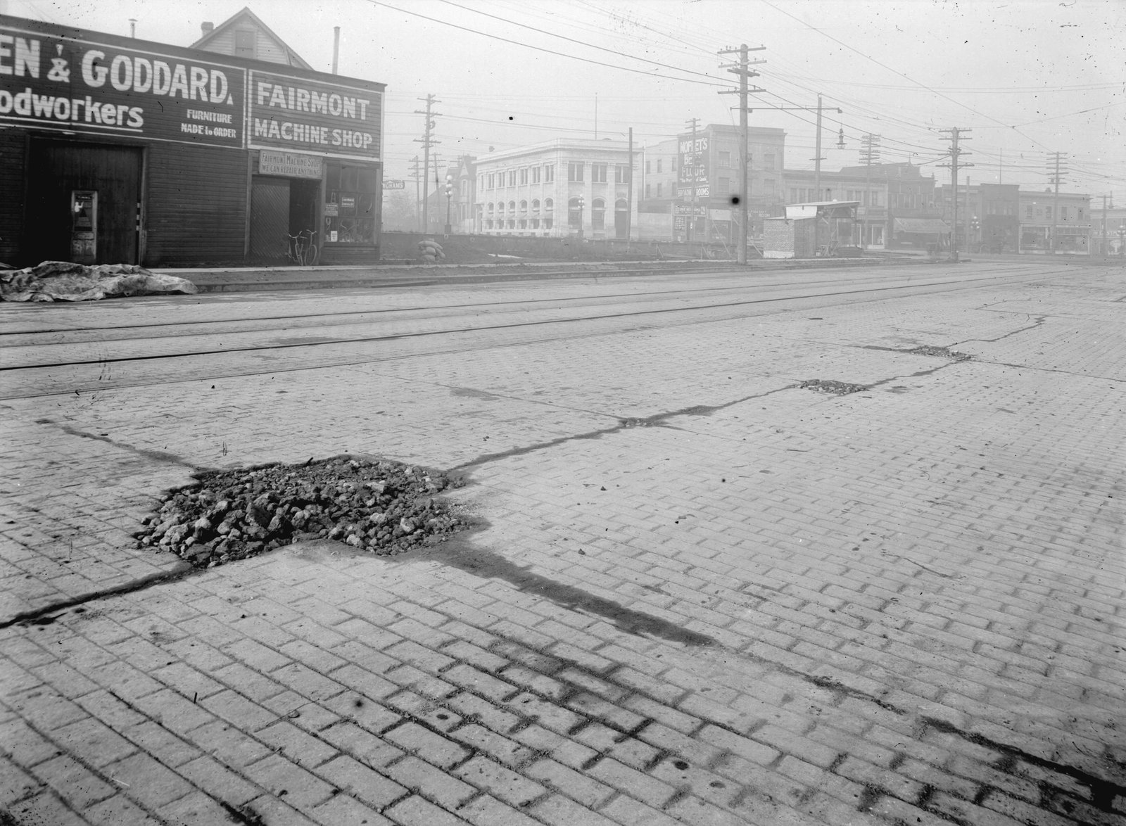
Before the first listing
1920: not in the name section, and the street list isn't read yet.
Chapter I
The Decks
the household, 1930
Mr C Deck lived at 204 Kingsway in 1930. The 1930 name section has no line for Mr C Deck. Its name section lists one more person here: Clara Deck, widow of M E Deck. It lists one more person here under another surname too.
1930
Street section, as printed
- Deck Mr C
1930
Also at this address
from the name section
The 1930 name section also gives this address for Clara Deck, widow of M E Deck. The line shares the surname of a household listed here before or after, but no first name or initial ties it to that household, so it stands on its own rather than in its chapter. Under other surnames it gives Annie L Cummings. The directory doesn't say whether this person boarded, rented a room or was family.
1930
Name section, as printed
Cummings Annie L r 204 Kingsway
Deck Clara wid M E h 204 Kingsway
Chapter II
The Haywoods
the household, 1935 to 1940
B Haywood is listed at 204 Kingsway in 1935; as far as the directory knew, a member of the family owned it.
1935
Street section, as printed
- *Haywood B
1940
B Haywood, in fuel, is listed at 204 Kingsway in 1940; as far as the directory knew, a member of the family owned it. The 1940 name section doesn't list this household.
Street section, as printed
- *Haywood Bfuel
Chapter III
The Podgers
the household, 1945
The Haywood years end in 1940, and the last directory whose names we show, 1945, lists G V Podger, the name marked *.
1945
Street section, as printed
- *Podger G V
The street
The 200 block, decade by decade
Kingsway, Mount Pleasant, every door the directories list
1930
Nine doors listed, three shops and businesses and two vacant.
North side
- 205Highway Serv Stn
- 225Carruthers J
- 227Carruthers J
- 245Butcher F
- 265Kway Tire Repair
South side
- 204Deck Mr C
- 210Ward W R
- 216vacant
- 220vacant
Street section, p. 103

1935
Nine doors listed, three shops and businesses and one vacant.
North side
- 205Highway Serv Sta, garage and oil
- 225*Carruthers J, garage
- 235*Carruthers J and one more
- 245*Butcher Mrs H S
- 265Kway Tire Repr
South side
- 204*Haywood B
- 210*Ward W R
- 216vacant
- 220Tyrrell W H T


1940
Eight doors listed and two shops and businesses.
North side
- 205Highway Serv Sta
- 225*Carruthers J, garage
- 235*Carruthers J and one more
- 245White N P
- 265Shell Oil, service station
South side
- 204*Haywood B, fuel
- 210Kimball Miss R I
- 216Silver Bell, restaurant
Street section, p. 97

1945
Eight doors listed and three shops and businesses.
North side
- 205Garside Serv Sta
- 225R B Ware Prods and two more
- 235*Carruthers J
- 245*Carruthers R H
- 265Ideal Utensil
South side
- 204*Podger G V
- 210Lanphier C G
- 216Pop's Bicycle Shop
Street section, p. 89

- 3of 4
- 3of 5
- 1of 5
Epilogue
The house today
The address is still in use, but the City's record dates the building to 1986: the house in these directories is gone.
Since 1945
- 1986Today's building goes up, by the City's record.
From City of Vancouver open data (Open Government Licence – Vancouver): the property tax report (BC Assessment's years, approximate for old buildings), business licences from 1997 (the kind of business only), issued building permits from 2017 and the heritage register.
The directories in this book stop in 1945. What they printed at 204 Kingsway is in the chapters before this one, every line with its page, so anyone can check it.
Sources
The page behind every line
Every year here comes from that year's printed city directory, held by the Vancouver Public Library. Canvassers compiled each one door to door, so a listing is who they recorded at the door, not a legal record of who owned or rented the house. Names are copied as printed, spellings and all. The street section lists each address in order; the name section lists each person with their work and address, which is where the jobs come from. h marks a householder, r someone living there, wid a widow. *: some member of the family owns the property, to the best of the directory's knowledge (its own mark, printed from 1935).
Anything we infer (a likely build date, a misprinted number, a renumbered address) is marked as inferred. Names are shown up to 1945; later years say only how the address was used. We link the library's page images and never reprint them.
Pages cited
- 1930Wrigley's British Columbia Directory: street section p. 103; name section p. 165, p. 179
- 1935British Columbia and Yukon Directory: street section p. 92, p. 93
- 1940British Columbia and Yukon Directory: street section p. 97
- 1945British Columbia and Yukon Directory: street section p. 89


The 1912 map: Goad's Fire Insurance Map, georectified by the City of Vancouver. Today's buildings, the heritage register and the years since 1955: City of Vancouver open data. Both under the Open Government Licence – Vancouver. The photograph: City of Vancouver Archives, CVA 789-48, public domain.
Something wrong, or a name you'd like removed? Tell us.
Compiled by AddressLore, Vancouver, November 2026. Set in Libre Caslon.
A house biography
Vancouver, from the city directories
Another address?
Every house has its book
Find yours by its address: